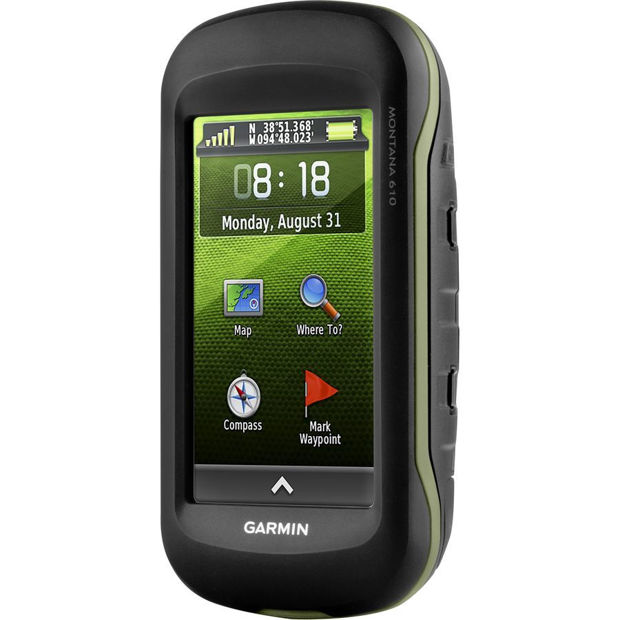


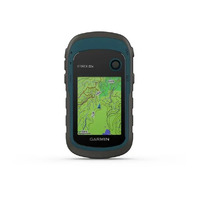
Garmin Montana 610 Handheld Gps Worldwide
or 4 payments of $193.25 with
 Info
Info
Take it hiking. Take it hunting. Take it on the water.
Montana 610 features a bold, colour touchscreen, dual-orientation display and includes a 1-year BirdsEye Satellite Imagery subscription. It also supports multiple mapping options like BlueChart® g2 and TOPO Australia and New Zealand.
Handheld includes 3-axis tilt-compensated compass, barometric altimeter and access to both GPS and GLONASS satellites for improved positioning and typically faster fixes.
See the Big View
Montana 610 features a 4-inch, sunlight-readable touchscreen display that offers crystal clear, enhanced colors and high-resolution images. Its easy-to-use interface means you’ll spend more time enjoying the outdoors and less time searching for information.
Mount Anywhere
With an array of compatible mounts, Montana 610 is designed for use on ATVs, in boats, as a handheld or in your car. Use the auto mount with City Navigator® NT maps for spoken, turn-by-turn driving directions or the rugged mount for your motorcycle or ATV.
Go Everywhere
Adding more maps to Montana is easy. Plug in BlueChart® g2 preloaded cards for a great day on the water, or load City Navigator map data for turn-by-turn driving directions. Add satellite images to your maps with BirdsEye Satellite Imagery (1-year subscription included). Or, transform paper maps into files you can download to your Montana with Custom Maps.
Share Wirelessly
With Montana 610, you can share your waypoints, tracks, routes and geocaches wirelessly with other compatible Garmin GPS users. Just press “send” to transfer your information to similar devices and let the games begin.
Keep Your Fix
With its high-sensitivity GPS and GLONASS reception, WAAS-enabled receiver and HotFix® satellite prediction, Montana 610 locates your position quickly and precisely and maintains it. Whether you’re in deep woods or just near tall buildings and trees, count on Montana to help you find your way when you need it most.
Navigate with Ease
Montana 610 has a built-in 3-axis tilt-compensated electronic compass, which shows your heading even while you’re on the move or not holding it level. The barometric altimeter tracks changes in pressure to pinpoint your precise altitude, or use it to plot barometric pressure over time to help keep an eye on changing weather conditions.
Double Your Power
With a one-of-a-kind dual battery system, the 610 gives you the option of using the rechargeable lithium-ion pack or traditional AA batteries.
Find Fun
Montana 610 supports paperless geocaching GPX files for straight-to-device uploading of geocaches from Geocaching.com. No more manually entering coordinates and paper print outs, Montana stores and displays key information, including location, terrain, difficulty, hints and descriptions. The track manager feature helps organize and navigate through waypoints/routes/ and track logs (easily start/stop recording tracklogs).
Plan Your Next Trip
Our free BaseCamp™ software lets you view and organize maps, waypoints, routes and tracks. This free trip-planning software even allows you to create Garmin Adventures that you can share with friends, family or fellow explorers. BaseCamp displays topographic map data in 2-D or 3-D on your computer screen, including contour lines and elevation profiles.
KEY FEATURES
- PHYSICAL DIMENSIONS 2.9" x 5.7" x 1.4" (7.48 x 14.42 x 3.64 cm)
- TOUCHSCREEN
- DISPLAY SIZE 2"W x 3.5"H (5.06 x 8.93 cm); 4" diag (10.2 cm)
- DISPLAY RESOLUTION 272 x 480 pixels
- DISPLAY TYPE bright, transflective 65K color TFT, dual-orientation touchscreen; sunlight readable
- WEIGHT 10.2 oz (289 g) with included lithium-ion battery pack; 11.7 oz (333 g) with 3 AA batteries (not included)
- BATTERY TYPE rechargeable lithium-ion (included) or 3 AA batteries (not included); NiMH or Lithium recommended
- BATTERY LIFE
- up to 16 hours (lithium-ion)
- up to 22 hours (AA batteries)
- WATER RATING IPX7
- INTERFACE high speed mini USB and NMEA 0183 compatible
- MEMORY/HISTORY 4 GB
- AUTOMATIC ROUTING (TURN BY TURN ROUTING ON ROADS) Yes (with optional mapping for detailed roads)
- MAP SEGMENTS 4000
- BIRDSEYE 250 BirdsEye Imagery files
- INCLUDES DETAILED HYDROGRAPHIC FEATURES (COASTLINES, LAKE/RIVER SHORELINES, WETLANDS AND PERENNIAL AND SEASONAL STREAMS) no (additional mapping needed)
- INCLUDES SEARCHABLE POINTS OF INTERESTS (PARKS, CAMPGROUNDS, SCENIC LOOKOUTS AND PICNIC SITES) no (additional mapping needed)
- DISPLAYS NATIONAL, STATE AND LOCAL PARKS, FORESTS, AND WILDERNESS AREAS no (additional mapping needed)
- EXTERNAL MEMORY STORAGE yes (32 GB max microSD™ card)
- WAYPOINTS/FAVORITES/LOCATIONS 4000
- TRACKS 200
- TRACK LOG 10000 points, 200 saved tracks
- ROUTES 200, 250 points per route; 50 points auto routing
(GM01939LP)
| SKU | GM01939LP |
| Model # | 010-01534-00 |
| Barcode # | 753759143312 |
| Brand | Garmin |
| Shipping Weight | 0.7000kg |
| Shipping Width | 0.162m |
| Shipping Height | 0.083m |
| Shipping Length | 0.165m |
Be The First To Review This Product!
Help other Xhunter Australia users shop smarter by writing reviews for products you have purchased.


