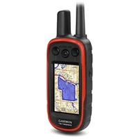
Garmin Tread Sxs Edition Satellite Navigation - 8 Inch Powersport With Group Ride Tracker #010-02507-20
Secure Payment Methods
Calculate Shipping
The Tread® - SxS Edition is an advanced 8” powersport sat-nav designed for off-road enthusiasts who demand durability and high performance. This device features a high-brightness HD color TFT display with a multi-touch interface, ensuring clear visibility and ease of use in various lighting conditions. Its rugged design includes an IPX7 water rating, IP6X dust rating, and MIL-STD-810 drop rating, making it ideal for extreme environments. The Tread® - SxS Edition excels in outdoor navigation with preloaded topographical maps, US public land boundaries, and motor-vehicle-use maps for various off-road vehicles, including motorcycles, ATVs, and full-size 4x4s.
The device supports advanced features such as Garmin Adventurous Routing™ and BirdsEye Direct Satellite Imagery, providing detailed and dynamic navigation options. It is also equipped with the Group Ride Tracker, allowing you to connect with up to 20 riders and track their locations with a 2.5-second update rate. With compatibility for backup cameras, Bluetooth® pairing, and smart notifications, the Tread® - SxS Edition ensures you stay connected and informed throughout your ride. Its versatile mounting options and rugged build make it a reliable companion for any off-road adventure.
KEY FEATURES
Dimensions: 8.1" W x 6.7" H x 1.2" D (20.7 x 16.9 x 3.1 cm)
Weight: 22.8 oz (646 g)
Water Rating: IPX7
Dust Rating: IP6X
Display Type: Multi-touch, glass, high brightness HD color TFT with white backlight
Display Size: 6.8" W x 4.2" H (17.2 cm x 10.8 cm); 8" diagonal (20.3 cm)
Display Resolution: 1,280 x 800 pixels
Dual-Orientation Display: Yes
Mounting: Locking magnet-assisted mount, Tube mount (1.5" - 2.375"), 1.5" ball adapter with AMPS plate
Drop Rating: MIL-STD-810
Battery Type: Rechargeable lithium-ion
Battery Life: Up to 6 hours at 50% backlight; Up to 1 hour at 100% backlight
Internal Storage: 32 GB
External Memory Storage: Yes (256 GB max microSD™ card)
Preloaded Maps: Street maps, topographical maps, US public land boundaries, private land parcel maps (parcels >4 acres), USFS Roads and Trails
Downloadable Satellite Imagery: Yes (BirdsEye)
TOPO Map Support: Yes
Sensors: GPS, Galileo, Barometric altimeter, Compass, 10 Hz multi-GNSS positioning
Outdoor Recreation Features: Point-to-point navigation, Navigate-a-track navigation, Turn-by-turn trail navigation
Camera Features: Backup camera compatible (BC™ 50 only)
Navigation Features: Garmin Real Directions™ landmark guidance, TripAdvisor® Traveler Ratings, Route shaping, Includes traffic (with Garmin Tread app), Lane assist with junction view, Bluetooth® pairing
Advanced Features: Smart notifications via app, Wi-Fi® map and software updates, Access to live services (traffic, weather, etc.), GARMIN ADVENTUROUS ROUTING™, Motorcycle or powersports specific POIs, Elevation profile, Round trip routing, Service History Log, Custom map support
RV Features: Specialized routing for vehicle size and weight, RV Parks & Services directory, Road elevations, Speed limit changes, Easy Route Planner with GPX file sharing
Adventure Features: Built-in inReach® Technology (requires subscription), Pair with Garmin PowerSwitch™ digital switch box, External GPS and inReach® satellite antenna compatibility, Group Ride Mobile (with Garmin Tread app), Track recorder (breadcrumbs), iOverlander™ POIs, Ultimate Public Campgrounds, Pitch and Roll gauges, Birdseye Satellite Imagery (download via Wi-Fi), Glove-friendly touchscreen
Group Ride Radio:
- Radio Frequency Band: MURS (151-154 MHz)
- Group Ride Range: Up to 8 miles (13 kilometers) with the antenna mount kit
- Group Ride Tracking: Up to 20 riders simultaneously
- Group Ride Update Rate: 2.5 seconds
- Radio Transmitted Canned Messages: Yes
Outdoor Applications: Dog tracking (when paired with compatible dog tracking system)
| SKU | GM126168LP |
| Model # | 010-02507-20 |
| Barcode # | 753759277550 |
| Brand | Garmin |
| Shipping Weight | 0.5000kg |